
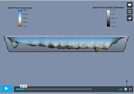
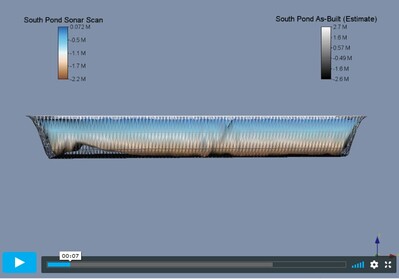
SCANNING AND MAPPING OF SETTLING PONDS
This is a comparison of the "As-Built's" of the industrial settling ponds with the sonar scan. The purpose of these scans was to calculate the volume of sediment and to determine where the build up was located.
The volume calculations and the 3-D imaging help to determine if and when dredging is required. It also helps to determine a budget for dredging based on the volume and the locations of major sediment build up.
All the data is quickly and safely acquired by the remote control (Air) Boat running a grid pattern on the surface of the pond.
![]()

![]()
HIGH RESOLUTION SONAR SEES THROUGH MURKY WATER...
EVEN THROUGH THE SEDIMENT
The side-scan and down-scan transducers create an amazing image of what is not seen because of murky water and the muddy sediment build up.
This object was a mangled pipe about 2-3 meters long. It was sticking out of the bottom of the settling pond but was not visible on the surface. If you look closely, you can even see the pipe through the sediment and mud which is less dense than the pipe.
OTHER USES TO CONSIDER
We feel that this technology could be used to identify objects (inanimate or animal / human remains) that are not visible from the surface or by divers searching in low visibility situations.
The sonar will read 100's of meters down but the best images are seen in 5-20 meter depths.
We would like to explore the possibilities of this and more in the future. If you feel this is something you would like to discuss, please don't hesitate to call us. (403) 872-5300.


Residential Ponds - Sonar Scan Showing Stormwater Sediment Build Up
This is a residential pond in Calgary Alberta that was set for dredging. We were able to show the exact sediment location and volume which helped them make pond maintenance decisions with accurate information.
Ultimately they did not dredge this "North" section of the pond but did dredge the other "South-East" half separated by a walk bridge at the part of the pond not shown on these slides.